


Télésiège de la Quoi - Col de la Molière

maupassant38
User
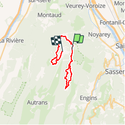

Length
21 km

Max alt
1644 m

Uphill gradient
356 m
Km-Effort
27 km

Min alt
1266 m

Downhill gradient
699 m
Boucle
No
Creation date :
2019-03-12 10:14:42.767
Updated on :
2019-03-12 15:34:34.679
2h37
Difficulty : Medium

FREE GPS app for hiking
 SityTrail
IGN / Geographical institutes
SityTrail Plus
The world is yours!
About
Trail Cross-country skiing of 21 km to be discovered at Auvergne-Rhône-Alpes, Isère, Autrans-Méaudre en Vercors. This trail is proposed by maupassant38.
Positioning
Country:
France
Region :
Auvergne-Rhône-Alpes
Department/Province :
Isère
Municipality :
Autrans-Méaudre en Vercors
Location:
Autrans
Start:(Dec)
Start:(UTM)
703608 ; 5011626 (31T) N.
Comments